“All I ask is a tall ship and a star to steer her by”
Sea Fever by John Masefield
By Linda Batchelor
On 30th July 2025 Michele Dougherty, Professor of Space Physics at Imperial College, London was appointed by King Charles III as Astronomer Royal, the first female in the three hundred and fifty year history of the appointment since its creation in 1675. The position of Astronomer Royal is as official advisor to the King on astrological matters and the post is a senior one in the Royal Household of the United Kingdom. Since 1972 it is now an honorary title without executive power but nevertheless the post carries with it recognition of scientific achievement and great prestige. The Astronomer Royal is the Senior Astronomer and there is a Junior Astronomer Royal for Scotland, an appointment created in 1834 and which has been held since 2021 by Catherine Heymans, Professor of Astrophysics at Edinburgh University.

Imperial College, Professor Michele Dougherty appointed as Astronomer Royal on 30th July 2025
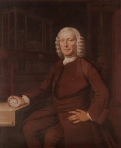
The role was created in 1675 by Charles II when John Flamsteed was appointed by the King as “Our Astrological Observer”, the more commonly known title of the Astronomer Royal until the late eighteenth century. He also became director of the Royal Observatory at Greenwich which was established a few months later. Flamsteed had become fascinated by astronomy as a young man and had written his first paper on the subject aged nineteen on the design and construction of an astronomical quadrant. Later in his career he was a Royal Commission Assistant investigating the issue of longitude. Flamsteed was appointed with an allowance of £100 per annum and with two assistants laid the foundations of the work at the Observatory which began establishing its reputation for precise astronomical calculations and observations and led to the contribution made by British astronomers to the developments in navigation.
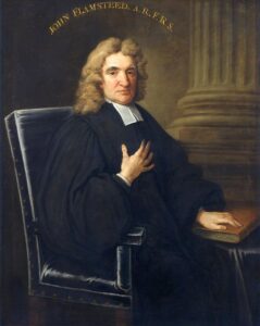
John Flamsteed FRS c 1712 Thomas Gibson (1680-1751) Royal Society
In 1662 the King had established the Royal Society by Royal Charter to explore aspects of science through discussion and experimentation. The Astrological Observer was appointed to advise the King on astrological matters and since one of the aspects of science to be considered by the Royal Society was navigation at sea which was closely linked to astronomy the matter became the concern of the Observer.
The challenges of navigation at sea were increasing in times of both peace and war and in an era when sea power was rapidly extending Britain’s interests in trade, exploration and overseas territory solutions became vitally important. Although mariners had mastered the calculation of latitude with various devices a major issue existed with determining longitude.
The Royal Warrant issued by King Charles on 4th March 1675 requested, therefore, that the Astrological Observer “apply himself with the most exact care and diligence to the rectifying of the tables of the motions of the heavens, and the places of fixed stars, so as to find the so much desired longitude of places for the perfecting of the art of navigation”.
The Warrant of March was soon followed on 22nd June by another Warrant “to build a small observatory within our park at Greenwich”. Flamsteed began his programme of observations immediate on appointment, initially in the White Tower at the Tower of London and then at the Queen’s House at Greenwich. The Observatory on the hill in the parkland at Greenwich, proposed by the Surveyor General of the Ordnance and designed by the architect, Christopher Wren and the scientist Robert Hooker, was ready for occupation by Flamsteed and his assistants in 1676.
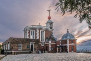
The Royal Observatory, Flamsteed House, at Greenwich
Navigation by the stars has a timeless tradition as is the linkage between astronomy and navigation. Observation of the sun, moon, planets and stars has always been a method of determining position and celestial navigation has been one of the key applications of astronomy. Celestial navigation relies on a knowledge of astronomy and the ability to calculate and interpret celestial data and has played a vital part in navigating the seas and exploration throughout history.
Over time and in many societies throughout the world there has been constant development to obtain better interpretation of data and improve technology to achieve greater accuracy in navigation at sea. It was one of the reasons that in Britain led to the creation of the role of Astronomer Royal and the Royal Observatory by the Royal Warrants with the concept that by making accurate astronomical observations improvements could be made to enhance navigation, cartography, instrument design and geomagnetism.
Today with the benefit of modern technology seafarers have range of options such as GPS and satellite systems, radar and sonar to navigate the oceans but historically there have been a whole variety of tools, the technology of the day, used ‘to track the motions of the heavens’ which have been developed and adapted for assisting with navigation.
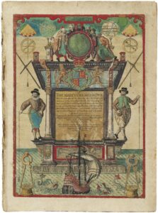
The Mariners Mirror, a Sea Atlas, 1584 (English Translation 1588) By Lucas Jansz Waghenaer Illustrated by Theodor de Bry showing many nautical instruments Society for Nautical Research.
The Astrolabe
The astrolabe, ‘the star taker’, is an astronomical instrument with great historical significance. Developed since the time of ancient Greece its use spread throughout the Islamic world and Europe and was used for all manner of tasks. As well as astronomical calculations and celestial mapping it had a place in architecture and construction, in calculating and telling time and in navigation on land and sea.
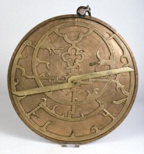
A 14th Century English Astrolabe Whipple Museum of Science University of Cambridge
It is a hand held device with rotating discs and rulers showing the position of astronomical objects and able to measure altitude above the horizon. It is a complex device with several different components. The mater is a disc which holds together all parts of the device with an outer ring inscribed in degrees and a scale for hours. The plate is a backing disc with a line representing the horizon and on top of this is the rete which is a cut out rotating plate. This creates a star map with pointers marking the positions of certain stars and there is also an elliptical ring to track the sun’s annual path from earth. A simple rule is there to locate positions on the plate and rete and relate them on the ring of the mater. The final part on the back of the mater is an alidade which has small pinholes to measure altitude of an object above the horizon.
The construction of an astrolabe, one of the earliest scientific instruments, required a high level of skills and craftsmanship. The instruments were admired for their beauty and were often embellished with artistic designs and engravings. Mastering the use of an astrolabe took much practice and expertise. These factors engendered a degree of mystic into the instruments and their use.
A simpler version of the instrument was developed as a mariner’s astrolabe and was principally used to determine latitude. Adapted for use at sea the instruments came into use from the latter part of the fifteenth century. They were perfected by Portuguese navigators and quickly became an essential aid to European navigators in the Age of Exploration.
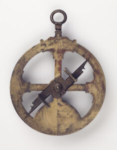
The mariner’s astrolabe was constructed with a cast frame, usually made of brass and with less complexity in design. The heavier parts were cut away making it easier for a mariner to use on a moving ship, especially in rough wind and weather. It was used to measure altitude of the sun at noon or a specific star at night to calculate latitude.
Quadrants, Octants and Sextants
Astrolabes were used as navigational aids until the middle of the eighteenth century but as maritime trade and exploration increased and empires grew so did the need for greater precision in navigation. The result was the development of instrumentation aimed at easier use for navigators to determine positions at sea. From the late sixteenth century instruments such as the quadrant, the octant and the sextant were part of this development especially in determining latitude.
The quadrant, using a 90o arc, was first introduced for astronomical purposes to measure the angle of the sun by Ptolemy the Graco- Roman scientist and astronomer around 150AD. Quadrants were developed and used by Muslim astronomers and at first they were large static reflecting instruments but smaller versions were also developed for ascertaining latitude by Arab sailors on the east coast of Africa and were adopted by European sailors in the following centuries.
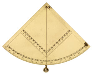
Captain John Davis was an Elizabethan ‘sea dog’, a contemporary of the Gilberts and Rayleigh, and a pilot and navigator in the age of maritime exploration. He had taken part in expeditions searching for the North West passage and had undertaken Dutch and English voyages to the East Indies. He produced a treatise ‘The Seamans Secrets’ and in 1594 had developed the back staff, a navigational a tool based on celestial observation. Known as the Davis Quadrant the instrument became widely used by mariners and led to the development of the octant in the mid seventeenth century.
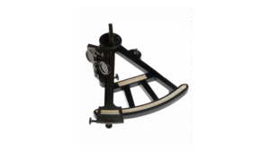
The octant is a smaller version of the quadrant based on an eighth of a circle and measures angles to 90o. A two mirror reflecting instrument for measuring the height of a celestial body above the horizon it was a popular and widely used nautical tool for determining latitude. The idea of such an instrument was based on ideas proposed but never taken further by Isaac Newton and Robert Hooke in the later part of the seventeenth century. In the 1730s the idea of the octant was developed independently and almost simultaneously by John Hadley, an English scientist and mathematician, and Thomas Godfrey, a glazier and amateur scientist, from Philadelphia in America. Representations were made to the Royal Society in London to confirm whose was the greater claim to the invention but unable to determine the matter the Society awarded both £200. However Hadley took the popular attribution of the invention. The octant usually constructed in wood was a practical and more precise alternative to the quadrant but there were still drawbacks especially regarding the on going challenge of determining longitude.
In 1747 Captain John Campbell RN of the frigate HMS Bellona had been the first to use a Hadley octant to measure the distance between the moon and fixed stars. His results were confirmed by the then Astronomer Royal James Bradley and the two went on to collaborate on observations at Greenwich on the distances of the moon and stars and of distances between the stars. On advice to the Board of Longitude from Bradley in 1756 Campbell, then in command of HMS Essex, was involved in sea trials of astronomer Tobias Mayer’s new lunar tables and reflecting brass circle. As a result Campbell made recommendations to the Board on improving the wooden octant and its construction. His suggestions of a reflecting instrument of one sixth of an arc measuring up to 120o with greater accuracy and made of brass were taken up by the Board. John Bird, the astronomical instrument maker was commissioned to build the new instrument and in 1759 produced the sextant which became Royal Navy standard issue for its navigators.
In 1789 Captain Bligh of HMS Bounty was set adrift by mutineers in the Pacific Ocean with eighteen of his crew in the ship’s longboat with only a compass and a sextant. Bligh was an accomplished navigator and with just those instruments and a pocket watch he completed a remarkable journey of 3,500 nautical miles to reach the Dutch East Indies.
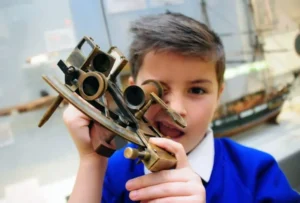
A schoolboy looking through a sextant on an educational visit to the National Maritime Museum Cornwall. NMMC.
Determining Longitude
The creation of the position of Astronomer Royal and the Royal Observatory in 1675 and the passing of the Longitude Act 1714 were all part of the challenge of determining longitude. The Act established a Board of Longitude with twenty two commissioners made up of parliamentarians, administrators, scholars and naval officers tasked with judging proposals, funding experiments and expeditions and rewarding schemes for ‘discovering longitude’. The publication of star catalogues and nautical almanacs and the development from the early angle finding instruments through to the sextant were aspects of meeting the challenge. However determining longitude remained difficult until a seaworthy clock was perfected.
The Marine Chronometer
This was the task undertaken by John Harrison from Barrow upon Humber. Dava Sobel in the book “Longitude” states that “He wrested the world’s whereabouts from the stars, and locked the secret in a pocket watch”. This marine chronometer was the solution to the problem with longitude.
John Harrison (1693 -1776) holding his marine chronometer Thomas King c 1767 Science Museum Collection
John Harrison, born in Yorkshire in 1693, was a carpenter and self-taught clockmaker who began building wooden clocks from 1713. In the 1720s he produced a series of precision longcase clocks which achieved remarkable accuracy. In response to the offer of a reward of £20,000 from the Board of Longitude to solve the longitude problem he aimed to devise a portable sea clock.
Such a clock would have to withstand conditions at sea, including constant movement, instability and rough weather as well as variations in temperature and atmosphere whilst maintaining accuracy in timekeeping. He was encouraged in his ideas by the Astronomer Royal who introduced him to George Graham the celebrated London watch and instrument maker who supported him with finance to build his first clock H1. This was built in Barrow upon Humber and brought to London in 1735 where it was displayed in Graham’s workshop. The Board of Longitude agreed to a sea trial of his clock and in 1736 Harrison embarked on a voyage to Lisbon aboard HMS Centurion. H1 did not perform well at first on the outward voyage although its perfomance improved later. On the return voyage on HMS Orford the results were good and using H1 Harrison was able to correct a mistake by the naval officers who misidentified the headland at the Lizard as Start Point some sixty miles off course.
Harrison returned to London to continue his efforts with producing an accurate sea clock. The Commissioners of Longitude ruled that the sea trial was insufficient but awarded him £250 to build an improved clock within two years. He produced H2 but discovered it was flawed and in 1740 began work on H3 which he continued to develop for the next twenty years. During that time he adopted a new type of watch balance with larger oscillations made by John Jeffreys and this became the basis of H4, his marine chronometer which resembled a large watch. It was trialled on a voyage to the West Indies in 1761 where it performed extremely well but although in 1765 the Board granted Harrison £10,000, they were reluctant to decide on whether the outcome had been fully achieved. This decision exacerbated what had been a constant and lengthy struggle between Harrison and the Board to establish his claim to finding the solution for longitude. When in 1772 the device was undergoing further testing at the Royal Observatory it was seen by King George III who was impressed and used his influence to secure the decision and the full reward for Harrison who at last had “solved the greatest scientific problem of his time”.
The Board of Longitude continued to test matters concerned with navigation including longitude, magnetic and astronomical theories. It also encouraged and supported expeditions by navigators, hiring astronomers and scientists for voyages such as expeditions by Cook in the 1770s, Vancouver in the 1790s and Flinders in 1801. It also became important in recording, cataloguing and registering navigational instruments and undertook collaborations with other astronomical institutions. The Board was abolished in 1828.
The linkage between astronomy and navigation was and still is the basis of navigation at sea. It is something that requires skill and mastery. Developments have continued to be made constantly, especially with modern technology such as GPS and electronic charting but the legacy of earlier technologies has enabled those advances and maintained the overriding criteria of accuracy and safety.
Postscript – Women in Astronomy
The headline for this Blog was the recent appointments of the two female Astronomer Royals for England and Scotland, roles which have previously been dominated by men. Despite the prominence of women in astro science today this is a major acknowledgement of the role women have played, officially and more often unofficially, in astronomy in Britain in the past.
An early contributor to the subject was Margaret Flamsteed, wife of John Flamsteed, the first Astronomer Royal. As well as being a place of work for John Flamsteed the royal Observatory in Greenwich was also a family home. Margaret, who was well educated, was close to the astronomical work of her husband, his assistants and pupils. After her husband’s death she was responsible with his assistants for the publication in 1725 of his catalogue of stars, his major work “Historia Coelestis Britannica” and again in 1729 for his “Atlas Coelestis” ensuring his astronomical legacy.
The first professional woman in astronomy in Britain was Caroline Herschel born in Hanover in Germany in 1750. She was the sister of William Herschel, a musician with an interest in astronomy, who became an organist in Bath. Caroline accompanied him to Bath to sing in his concerts and shared his interest in astronomy. In 1781 William gave up his musical career after discovering the planet Uranus using a telescope and took up astronomy professionally. He was appointed as Court Astronomer to the Royal Family at Windsor and set up his observatory there. He trained Caroline as his assistant and she ultimately discovered eight comets and two thousand five hundred nebulae during her inspirational career. In 1787 when King George III granted her a salary as William’s assistant, she became the first woman to earn a living from astronomy. She continued working in her own right after her brother’s death and in 1828 was awarded the Royal Astronomical Society’s Gold Medal and in 1835 became an Honorary Member of the RAS. She died in 1848 after a celebrated and groundbreaking contribution to astronomy.
The Royal Observatory had employed only male Astronomers and assistants until in 1890 the Astronomer Royal William Christie FRS decided to recruit a group of “Lady Computers” who had all studied mathematics at the all-female colleges of Girton or Newnham in Cambridge. They had all studied to degree level but as women were not eligible for the degree award, the status until 1948. The Royal Observatory had newly taken delivery of an astrographic telescope and Christie wanted to set up an astrographic department to observe and take photographs of the sky. Funding was difficult but costs could be less by employing women at lower salaries than men and four women were recruited. The most senior was Isabella Clemes who was aged forty-three. The other three were Harriet Furniss, Edith Rix and Alice Everett, all in their early twenties. Isabella, Harriet and Edith had all studied at Newnham and Alice at Girton. Isabella and Harriet were born and had lived in Cornwall, Isabella in Liskeard with family in St Austell and Harriet in Truro, Edith was from Beccles in Suffolk and Alice from Glasgow. A fifth young woman Annie Russell from Strabane had also been at Girton and was also on the team from 1891. Annie Russell married a colleague Walter Maunder in 1895 and by then all the women had all left Royal Observatory employment for elsewhere.
Annie Russell, as Annie Maunder, had been required to leave her post on marriage but she continued to be closely involved with astronomy through her husband and through her own distinguished work in with solar eclipse photography.
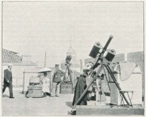
Annie Maunder at work during a solar eclipse in Algiers in 1900. Photographed by H Ellis for the British Astronomical Association.
Gradually since that time the numbers of women studying and working in astronomy and related areas have grown and these recent appointments are an indication of that development.


